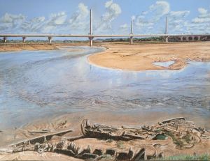
Mersey Flats
This painting shows the River Mersey from Spike Island in Widnes at low tide. The Mersey Gateway Bridge, which opened in 2017 can be seen in the background. In the foreground are Mersey Flat Boats in ruins. The Mersey Flats were the main transport for the area in the 18th, 19th and well into the 20th century. They were mostly abandoned by around 1970 because of improved roads and road transport technology. They could carry up to 300 tons of cargo, about 10 times what a large modern lorry can carry.
The boats were a 2 or 3 masted double ended barge with a round bilge and flat bottom. Built very solidly, they were able to sail coastal waters as well as local rivers. Mostly they were family run, with skills and knowledge passed down through the family.
The Sankey Canal, formerly known as the Sankey Brook Navigation, was built for the Mersey Flats to transport coal and other goods to and from St Helens. Opened in 1757 it was the first canal of the industrial revolution. The canal also ends at Spike Island, where the locks are still used. Most of the canal is now disused, and the part to Spike Island was a later addition and was not part of the original Sankey Brook Navigation, which when opened had its locks to the river a few miles upstream at Warrington next to where the Sankey brook enters the River Mersey.
The canal was originally built with all swing bridges to allow for the large masts of the Mersey Flats. The later added Sankey Viaduct rail bridge was built with a 70-foot headroom to allow for the boats to pass under.